Monday 15 December 2014

Morocco: Finally into the Sahara! - Part One

But first up a brief account of failure number three to access our planned Sahara route.  Shortly after departing the sand dunes at Erg Chebbi we came across the first indication that we may yet again fail to access the Sahara desert - the high ford in the photo below.


There was a small queue of traffic waiting for the water to drop and initially the policeman said we could not cross, though after inspecting our car he decided that we could.  The water didn't really look that high, but given the policeman's cautiousness I decided it was better to wait for someone else to go across first. Soon enough two Toyota Landcruisers crossed with ease, giving me the confidence to go across too.  It turned out not to be difficult.


But getting past the ford didn't ultimately help us very much, because upon reaching the small village of Taouz we needed to cross the oued (means river in Arabic) Ziz and that proved impossible.  A local man named Mohammed approached and told us the route was closed.  Still we wanted to see the river for ourselves and so he took us to it, riding ahead of us on his motorbike.  It was difficult enough just trying to drive to the river let alone actually cross it.  The ground was a sodden mess, as it would all have been beneath the flood waters just days earlier.  And although the Ziz had receded back within its river banks, it was still a high wall of brown muddy water.  Mohammed invited us back to his house for tea and to show me his Michelin map. I knew to be aware some sort of sales pitch would likely be involved, but I was nonetheless keen to accept his offer and see his house.

Approaching the village near Taouz where Mohammed's house is.


Mohammed served us tea in the traditional Moroccan way and fed us home made bread with left over tagine.  The photo below shows his living room, which apart from the wool rugs on the couch and a small table is unfurnished and undecorated. The floor is concrete.  I suspect Mohammed's house is a good example of what other houses are like in the small villages we pass through.

Mohammed has only lived in a house for the last ten years.  Before that he was a nomad and lived in tents in the desert.  His background makes him an ideal candidate for his current line of work, which is working as a guide to people looking to cross the desert - just like us.  And of course this is the main reason we were invited back for tea.  As we examined Mohammed's Michelin map he was helpful in giving us ideas, including when the river might drop low enough to cross, or indeed how to get around it.  We discussed some ideas as to how he might guide us, riding his motorbike ahead of us.  But in the end I preferred to go it alone, taking a route that would avoid having to cross the Ziz - or the even bigger river beyond that with a river basin 5km wide!


This ended up being another day that we failed to access the Sahara, but not a day wasted, as being taken into the home of a local was very interesting.  We pass through villages filled with simple housing almost daily, but the opportunity to go inside one was very much appreciated.  We returned to Merzouga for the night and I got busy plotting a new route into the Sahara that we would follow the next morning.

Next Day

The following morning we were on the road reasonably early, hopeful that my new route into the Sahara (our 4th attempt!) would prove successful.  The new plan was to return back down the paved road in the direction of Zagora far enough to get across the biggest rivers, then turn south and head into the desert.


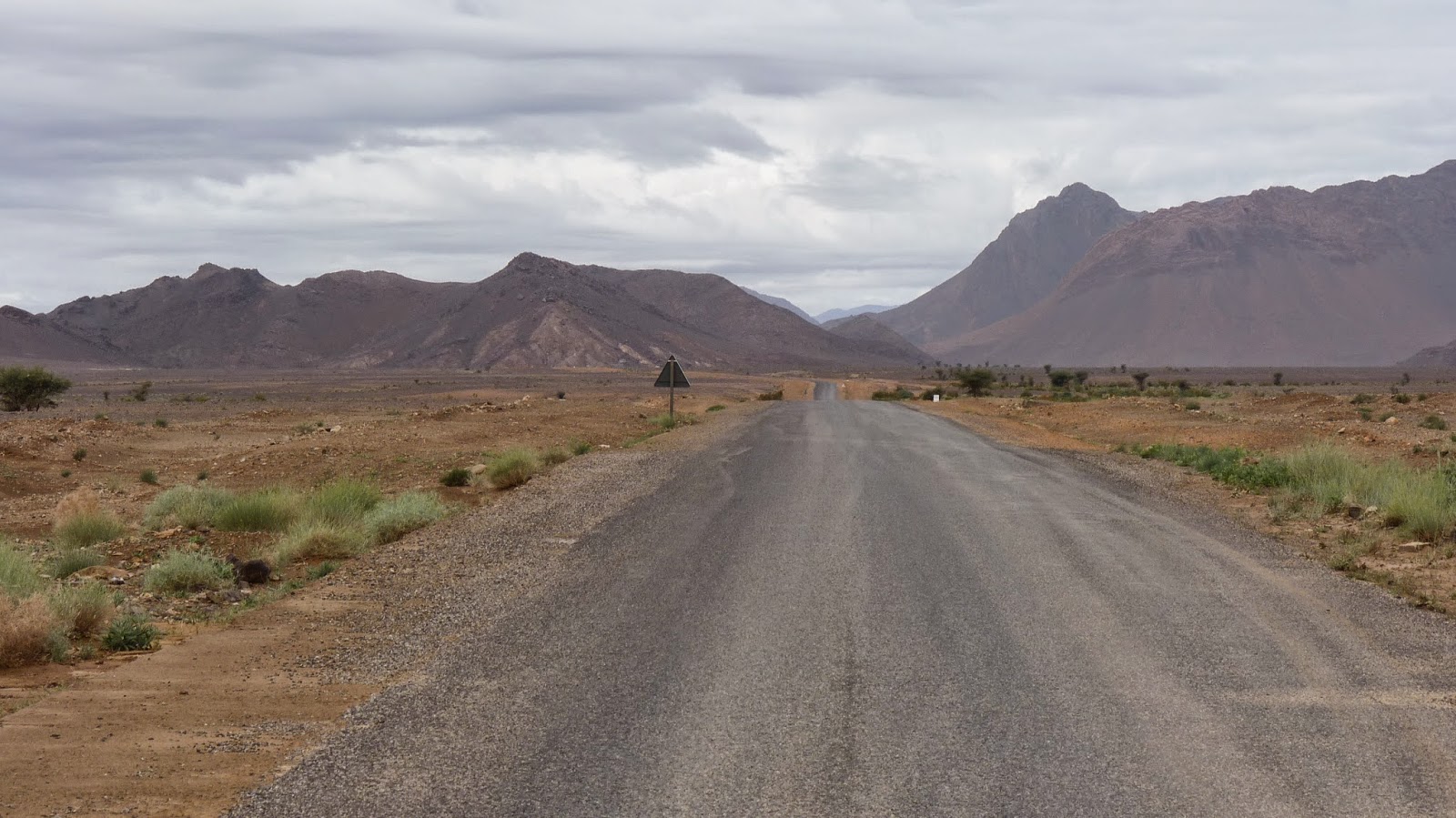
After turning south we followed a dirt road towards the desert and passed through a number of remote villages along the way.  Many of the villages were recovering from the flooding and still busy clearing up fords and bridges.


Eventually we turned off the dirt road and began to follow a track further into the desert.


Stopping for lunch.


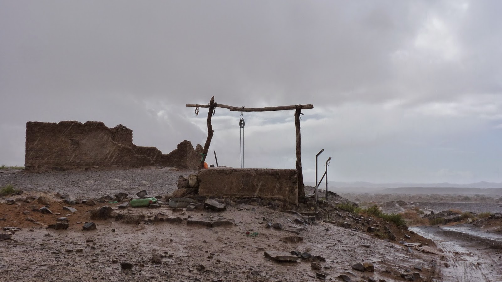
Old ruined kasbahs such as the one shown below are not uncommon.  We went over for a closer look at this one.


The photos that follow speak for themselves.  Basically the further south we went towards the Sahara the more remote and isolated it became.


At least there's one tree out here if shade is needed!


Getting near the desert town of Oum Jrane.


Approaching Oum Jrane.


Pausing safely outside of Oum Jrane, out of the reach of dozens of over excited children!  After studying the maps it turned out we needed to go back through Oum Jrane again.....


Now on the other side of Oum Jrane and back on our route.


You are very reliant on GPS out here.  The tyre marks go off whichever direction, sometimes aligning to our route and sometimes not.  Without GPS it would be easy to get lost or confused out here.  But on the plus side you don't even need a track to follow.  The tyre marks give some comfort that you're following an established route, but wherever the tyre marks stopped aligning with our intended route I could just veer overland across the plains until we found other tyre marks that aligned with GPS waypoints I had plotted.


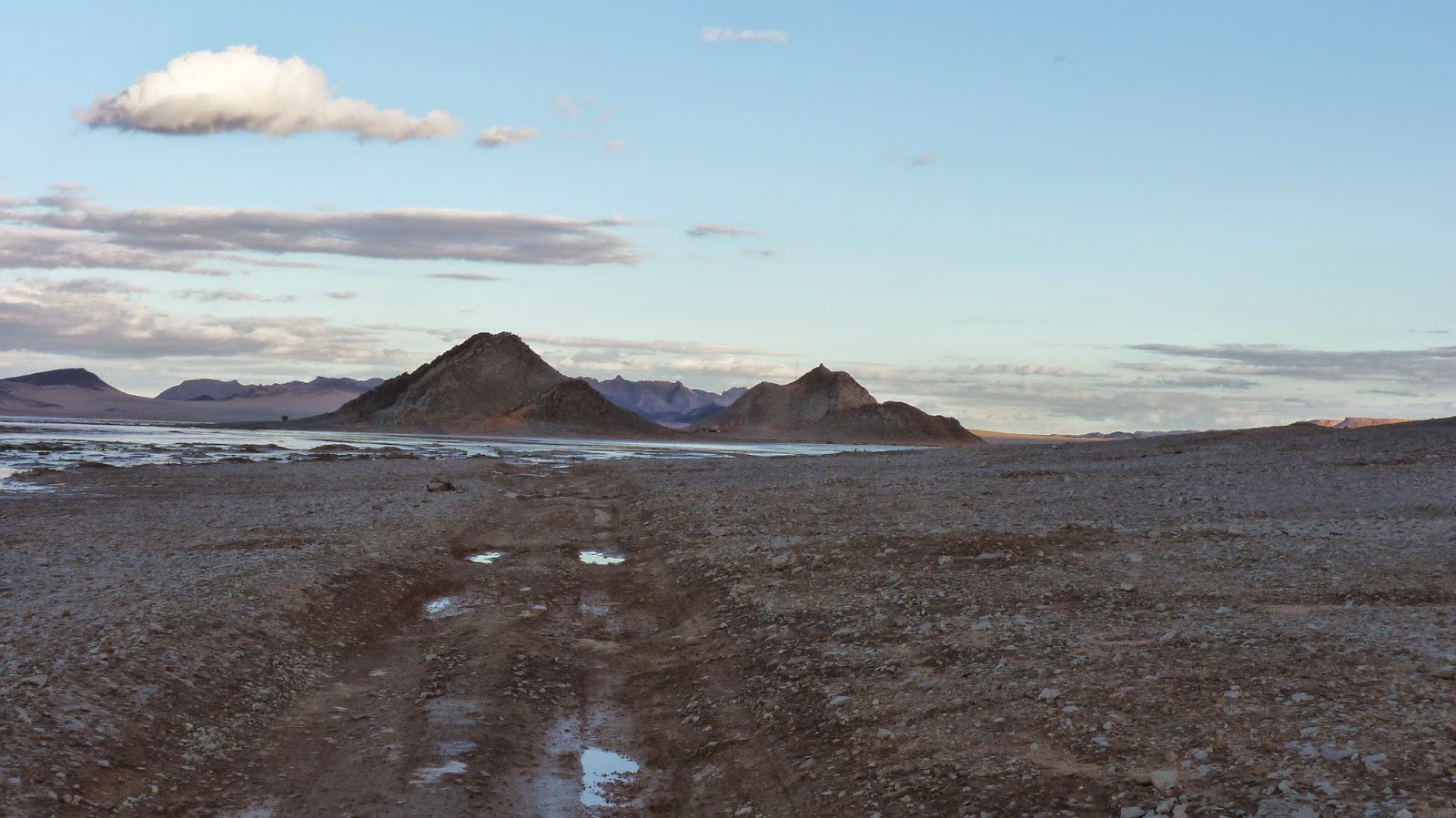
This lake is nearly always a dry lake bed.  But with all the heavy rains and flooding in Morocco this lake had unusually filled up.  We planned to visit a desert town on the far side of this lake bed and my books indicate that ordinarily you can just zip across the dry lake bed, but not now.  Getting to the town would have meant a long drive around the lake so we gave it a miss.  Part 2 of this blog has photos of the town from across the lake.


 This next photo was taken the following morning at sunrise.


I took the photo below from a sandy/rocky outcrop near our campsite.  On the far side of the mountains visible in the photo lies the border with Algeria.  Although some tourists have been put off coming to Morocco owing to extremists across the border in Algeria and beyond, I felt at all times safe in Morocco. Despite the remoteness of our camping spot, I knew we were not far from a Moroccan army checkpoint because we drove into it by mistake and were turned around by armed soldiers.


See Part Two for the remainder of this route.

Friday 12 December 2014

Morocco: Erg Chebbi and Merzouga

Given the flooding we decided to spend a couple of days in Merzouga by the Erg Chebbi sand sea before commencing our intended Saharan overland route.  Erg Chebbi is one of two sand seas in Morocco and it is the bigger/higher of the two.  My visual impression was that Erg Chebbi was massive, but you need only look on Google Earth to see that other Saharan sand seas across dangerous borders, such as Algeria, are actually many times the size of Erg Chebbi.  But this fact made exploring Erg Chebbi no less of an adventure and no less of a challenge!


On our first full day in Merzouga we set off to circumnavigate Erg Chebbi.  We also drove up and into the sand quite a way, but I was being very cautious.  I know some tourists come here, either in their own 4wd or a rented one, get too carried away and end up rolling the vehicle.

In the lower half of the photo below you can see tyre tracks - this helps to better appreciate the scale of this pile of sand!


The next few photos tell an interesting story.  I decided to head into the Erg following a set of tracks etched into the sand.....


.... and they ended at this tree.


But it turns out there is a local man who lives in the tree and as you can see in the next few photos he lives quite well.  He gave me a tour of his home.


The next two photos are his living room area.  You can see parts of the tree sticking through the thick wool blanket walls.


And this is the bedroom


We continued our journey and eventually stopped for a picnic here.


One annoyance/peculiarity with Morocco is that just when you think your alone in an isolated spot, someone turns up out of nowhere - usually to sell you something.  The two guys pictured below turned up and set up an impromptu craft stall during our picnic and kept calling us over to buy something.


Beyond the sand are vast rocky plains typical of parts of the Sahara beyond.  Here we are looking back at Erg Chebbi.


From here we continued to the south, where we drove through a couple of abandoned villages.  Though having said that, it turned out that some of the dwellings were actually being inhabited still.


We believe the building left of the car in the photo below was being lived in.


The photo below shows a typical well.


You can see in these photos how wet the ground is from the unusual rains Morocco had been experiencing around this time.  Ordinarily this would all be completely dry, with rain seldom seen in these parts.  As we continued along here we had a mini flash flood caused by a brief heavy downpour and though we were only a very short distance from rejoining the sealed road we ended up in mud part way up the wheels.  Not wanting to get bogged we turned around and returned to Merzouga across the Erg Chebbi.  (Dirt just turns to mud when it gets wet, whereas sand actually gets firmer and easier to drive on after rain).


The photo below shows the riad where we stayed.  It is right at the edge of the sand dunes.


When we returned to our riad the two guys who were our hosts felt inclined to take their landcruiser into the dunes.  I think they ordinarily charge for guided trips, but on this day they just wanted to go for a blast and since I had recovery ropes we went out together for a bit.  The terrain on the way to the dunes was more difficult than it looked - if you go too slow you start to sink in yet if you try to accelerate, rather than speed up you just start to dig down - thus a fine balance needed to be achieved.


The next day was back to a full blue sky and warm sunshine as we prepared to depart from the riad.  This was to be our third attempt to enter the Sahara and commence a two day overland route.  Unfortunately this ultimately failed yet again due to flood waters, however our plan to go high into the sand sea before leaving the area proved successful at least.  In this blog post I'll focus on our expedition up the sand dunes and leave the later part of this day to the next blog.


Stocking up with supplies on the main street in Merzouga before heading back into the sand sea.


Finding a route up and through the sand dunes isn't as easy as it looks from a distance and in practice it turns out to be a bit like a maze.  It also involves quite a bit of walking to the top of sand dunes to check what's on the other side.  You can't just go blasting up and down sand dunes at will, or you may go down something much steeper than you should.  For instance if you fail to plan adequately you could end up inside a bowl shaped sand dune formation that is too steep to climb on all sides - if you do that then that's where you'll stay!  4wding on sand is very different from any other terrain and I don't have that much experience with sand dunes, hence I was being cautious.


As so often happens in Morocco, someone eventually turned up to offer guidance.  Initially I was very reluctant to deal with this 'guide', who happened to be about 18 years old and riding a mountain bike.  I didn't doubt he knew a route through the sands, but I was concerned he wouldn't appreciate what it was like to drive a vehicle in the sands and might lead us somewhere we wouldn't/couldn't follow.  We especially don't like side slopes too much, yet these are unavoidable since you aren't supposed to drive directly over the sand crests - you can get bellied on those.  And it's on too steep side slopes that overzealous 4wd'ers sometimes roll their vehicles.  Eventually I agreed to let him guide us, as I could always choose to stop if it got uncomfortable.  This proved a very good decision, as he did find us a suitable route and was generally very helpful.  This doesn't mean it was all easy though and for one long steep climb I had to keep deflating the tyres before we could get all the way up - we failed 3/4 of the way up that slope about three times before conquering it.  I knew in theory that tyre pressure should do the trick, but trying it myself in practice was illuminating because once I had the tyre pressure right we went straight up it no problem.

We drove well into the dunes, but decided to walk rather than drive to the top of what I believe was the biggest dune at Erg Chebbi - tyre marks indicated it was possible to drive, but I wasn't game to try it and Sylwia wasn't keen either.


Morocco: Western Sahara: Tan Tan - Alsa

Our next route was taking us from Tan Tan (the end of first route) across the Western Sahara to a town called Alsa which Chris Scotts whose...